Scientists are trying to fathom what is causing extreme variations in British weather
 |
| The River Thames
The transformation of the British landscape over the last 12 months has been dramatic.
At the end of 2011, the nation was caught in the grip of one of the severest droughts on record. Low rainfall over the previous year had reduced water levels in rivers and reservoirs to exceptional levels. The year ahead promised to be one of parched landscapes, hosepipe bans and streams turned to trickles. There could have been widespread consequences for farmers, food production, tourism, industry and domestic life, warned officers from the Environment Agency.
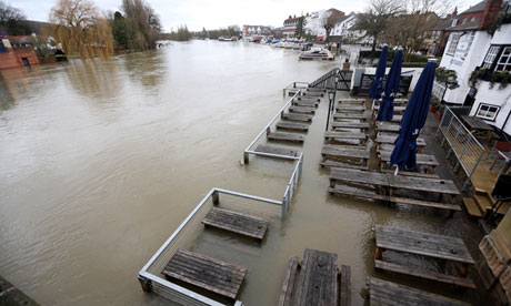
Today, the country is in a very different state. Villages across much of the UK have been flooded and cut off; railway lines have been closed; hundreds of flood alerts have been issued by the Environment Agency; homes have been evacuated and commuters and travellers have been forced to abandon plans for the festive season as sections of the transport network have ground to a halt. Today, the UK is on the brink of having had its wettest year since records began in 1910.
It is an astonishing change of fortunes. Last year was the driest on record in England and Wales for 90 years. This year will be one of the wettest. The question is: what has brought about this remarkable transformation?
According to experts, the key changes in Britain's weather occurred in early summer. The past couple of weeks may have seen momentous downpours across much of the country, with south-west England bearing the brunt of the grim weather, but it was record falls over the months between April and June that brought UK figures to their highs for 2012 and have raised river and reservoir levels to brimming point.
"The early summer months were the ones that turned drought to deluge in the UK," said Helen Roberts, a forecaster at the Met Office.
"As to the cause, the jetstreams that sweep high over the country were largely to blame. Jetstreams carry ribbons of air at high speeds and altitudes and normally trap regions of high pressure over Britain in summer," she said. "But this year the jetstreams trapped a region of low pressure over the country for several months in summer and that, in turn, brought all that rain to the country."
As to the reason for the change in jetstream behaviour, several suggestions have been put forward. These include the proposal that rising temperatures in the Arctic – triggered by increasing levels of manmade greenhouse gases in the atmosphere – could be destabilising jetstream patterns. However, scientists stress that more research is needed.
|


No comments:
Post a Comment