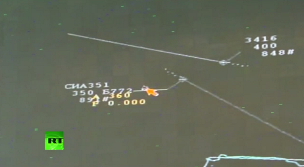
Kiev must explain why the military jet was tracking the passenger airplane, the Russian Defense Ministry said.
“A Ukraine Air Force military jet was detected gaining height, it’s distance from the Malaysian Boeing was 3 to 5km,” said the head of the Main Operations Directorate of the HQ of Russia’s military forces, Lieutenant-General Andrey Kartopolov speaking at a media conference in Moscow on Monday.
“[We] would like to get an explanation as to why the military jet was flying along a civil aviation corridor at almost the same time and at the same level as a passenger plane,” he stated.
At the moment of the MH17 crash an American satellite was flying over the area of eastern Ukraine, according to Russia’s Defense Ministry. It urged the US to publish the space photos and data captured by it.
 Radar stations of the air defense in Donetsk Region, 5km north of
Donetsk city, on July 14, 2014.Photo courtesy of the Russian Defense
Ministry
While the third picture shows the location of the air defense systems near Donetsk, he explained. In particular, one can clearly see the self-propelled system, about 60 units of military and special equipment, he elaborated.
 Buk missile defense units in Donetsk Region, 5km north of Donetsk
city, on July 14, 2014.Photo courtesy of the Russian Defense Ministry
“Images from this area were also made on July 17. One should notice that the missile launcher is absent [from the scene]. Image number five shows the Buk missile system in the morning of the same day in the area of settlement Zaroschinskoe – 50km south of Donetsk and 8km south of Shakhtyorsk,” the Kartapolov said
 No Buk missile defense units in Donetsk Region, 5km north of Donetsk
city, on July 17, 2014.Photo courtesy of the Russian Defense Ministry

“A Ukraine Air Force military jet was detected gaining height, it’s distance from the Malaysian Boeing was 3 to 5km,” said the head of the Main Operations Directorate of the HQ of Russia’s military forces, Lieutenant-General Andrey Kartopolov speaking at a media conference in Moscow on Monday.
“[We] would like to get an explanation as to why the military jet was flying along a civil aviation corridor at almost the same time and at the same level as a passenger plane,” he stated.
At the moment of the MH17 crash an American satellite was flying over the area of eastern Ukraine, according to Russia’s Defense Ministry. It urged the US to publish the space photos and data captured by it.
‘Ukrainian Buk missile system transported to militia-held area’
Buk missile defense units in Zaroschinskoe, 50km south of Donetsk city and 8km south of Shakhtyorsk, on July 17, 2014.Photo courtesy of the Russian Defense Ministry
The question that has to be answered is why the missile system appeared in the area controlled by the local militia forces shortly before the catastrophe, he stated. Images taken on July 18 show that the missile systems left the area of the MH17 crash on July 17, the military official said.
Another image shows a radar station near Donetsk.
While the third picture shows the location of the air defense systems near Donetsk, he explained. In particular, one can clearly see the self-propelled system, about 60 units of military and special equipment, he elaborated.

“Images from this area were also made on July 17. One should notice that the missile launcher is absent [from the scene]. Image number five shows the Buk missile system in the morning of the same day in the area of settlement Zaroschinskoe – 50km south of Donetsk and 8km south of Shakhtyorsk,” the Kartapolov said


No comments:
Post a Comment